The missing factor preventing the BoM from declaring an El Nino event
By Mike Foley
The Bureau of Meteorology has become an outlier among global weather agencies by refusing to declare an El Nino event, despite record-breaking heatwaves torching long-standing temperature records around the world.
El Ninos don’t hit maximum power until ocean and atmospheric conditions occur simultaneously to deliver the twin dreaded effects of the infamous weather system — high temperatures coupled with prolonged dry periods.

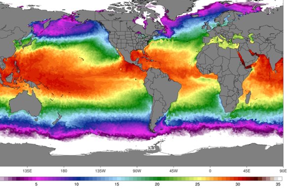
As oceans and land have warmed to near-record temperatures, most weather agencies have declared an El Nino event is underway. But Australia’s Bureau of Meteorology is waiting for one more crucial factor.
“I agree with the Bureau, it’s a coupling phenomenon it’s not just the ocean or the atmosphere” said UNSW Canberra climate scientist Sarah Perkins-Kirkpatrick. “In first year climate science degrees you learn that it’s a coupled phenomenon.”
In Australia, climate scientists talk about the El Nino-Southern Oscillation rather than El Nino weather cycles. That term represents the need for the right ocean and atmospheric conditions to happen simultaneously to drive the weather system that often delivers heatwaves and droughts.
The first factor the bureau looks for is elevated sea surface temperatures in the central and eastern Pacific Ocean. The second is weakening of trade winds that blow around the equator in the Pacific Ocean, symptomatic of a negative cycle in the Southern Oscillation, which means that moisture in the atmosphere that typically rains on Australia’s east coast doesn’t arrive.
This combination of hot seas and weak trade winds is known as “atmospheric coupling”.
While sea surface temperatures are soaring and hot water is pooling in the eastern Pacific, along the west coast of South America, trade winds are still blowing from the east in the Pacific at the equator and bringing hot moist air to eastern Australia. In other words, only one of the two conditions for El Nino-Southern Oscillation are being met.
However, the Bureau’s El Nino watch is set to “alert level” in recognition of the potential for an event to begin. Alert level warnings have been followed by an El Nino 70 per cent of the time.
Monash University climate scientist Shayne McGregor said there was no guarantee the atmospheric conditions would kick in, with a negative phase of the Southern Oscillation causing the trade winds to weaken, but previous experience showed that an El Nino event still had time to develop before the coming summer.
“If you look through the past when we’ve been in a similar situation, more times than not, it goes into an El Nino event,” McGregor said.
Risk Frontiers climate scientist Stuart Browning said weather agencies based in the northern hemisphere, like the World Meteorological Organisation and the United States’ National Oceanic and Atmospheric Administration, focus primarily on sea surface temperatures.
Elevated sea temperatures on their own can contribute to heatwaves in the northern hemisphere.
“They’re looking at it very much from North American and European perspectives. What really matters to them is the sea surface temperature in the central and eastern Pacific and they use that pretty much as their only indicator of whether it’s going to be El Nino,” Browning said.
“In 2014 there was a similar situation where all of the world’s organisations were projecting a really strong El Nino to happen and the bureau held off and said, ‘look, our models just aren’t showing that’. And it didn’t end up developing until a year later.”
However, despite the lack of an El Nino declaration, the bureau is forecasting hot, dry weather in coming months. It said there’s an 80 per cent chance of above-average temperatures between August and October across most of Australia and a 60 to 80 per cent chance of below-average rainfall.
The Morning Edition newsletter is our guide to the day’s most important and interesting stories, analysis and insights. Sign up here.